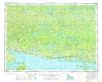
1961 Map of Blind River
USGS Topo · Published 1976About this map
Mississagi Provincial Forest dominates the northern reaches of this mid-century survey, a wilderness landscape defined by a dense network of water bodies like Wakomata Lake and Matinenda Lake. Along the northern shore of the North Channel, the industrial and transport corridor of the Canadian Pacific railway connects settlements from Bruce Mines and Thessalon to the mining hub of Elliot Lake. This era shows the rugged transition from the forest economy to the mid-century mining boom, centered around the rocky terrain of the La Cloche Mtns.
Find a feature on this map
123 named features on this map. Tap any name to fly to it.
Don’t see what you’re looking for? This feature index may not catch every label — zoom into the map to look around manually.
Map Details
Editions of this 1961 Blind River Map
3 editions found

Other maps of this area

1919 · Neebish
USGS Topo · 1:62,500

1941 · Neebish
USGS Topo · 1:63,360

1951 · Lake George
USGS Topo · 1:62,500

1953 · Munuscong NE
USGS Topo · 1:24,000

1954 · Alpena
USGS Topo · 1:250,000

1954 · Sault Sainte Marie
USGS Topo · 1:250,000

1955 · Cheboygan
USGS Topo · 1:250,000

1956 · Sault Sainte Marie
USGS Topo · 1:250,000

1957 · Alpena
USGS Topo · 1:250,000

1957 · Sault Sainte Marie
USGS Topo · 1:250,000