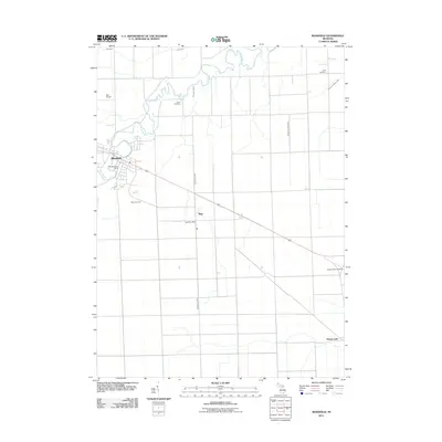
2011 Map of Blissfield
USGS Topo · Published 2011About this map
The River Raisin meanders through this agricultural landscape in southeastern Michigan, anchoring the settlement of Blissfield as it appeared in the early 21st century. The map reveals a highly structured grid of section lines and drainage systems, such as Camp Drain and the Burton and White Drain, which define the region's productive farmland. Small communities and rural hubs like Riga and Ottawa Lake are detailed, showing the placement of essential civic landmarks including the Blissfield Post Office and the Riga Post Office. Local history is deeply etched into the land through numerous burial grounds, including Crane Cemetery, Logan Cemetery, Riga Cemetery, and Pleasant View Cemetery, providing valuable points of reference for genealogists. To the northwest, Betz Airport stands as a notable modern landmark amidst the predominantly rural landscape, while Floodwood Creek serves as a primary tributary through the central fields.
Find a feature on this map
14 named features on this map. Tap any name to fly to it.
Don’t see what you’re looking for? This feature index may not catch every label — zoom into the map to look around manually.
Map Details
Editions of this 2011 Blissfield Map
This is the sole edition of this map. No revisions or reprints were ever made.
Other maps of this area

1900 · Toledo
USGS Topo · 1:62,500

1911 · Swanton
USGS Topo · 1:62,500

1912 · Dundee
USGS Topo · 1:62,500

1914 · Swanton
USGS Topo · 1:62,500

1926 · Dundee
USGS Topo · 1:62,500

1935 · Berkey
USGS Topo · 1:24,000
1937 · Sylvania
USGS Topo · 1:31,680

1939 · Berkey
USGS Topo · 1:31,680

1939 · Blissfield
USGS Topo · 1:62,500
1939 · Dundee
USGS Topo · 1:62,500