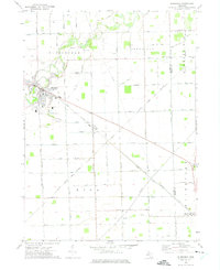
1972 Map of Blissfield
USGS Topo · Published 1975About this map
The Raisin River winds through the heart of this southeast Michigan landscape, defining the character of Blissfield and the surrounding agricultural townships. In the early 1970s, the area remained a strictly organized grid of rural roads and drainage systems like the Kellar and Riga Drain, supporting the fertile plains of Riga and Deerfield. Transport and industry are marked by the presence of Betz Airfield and the diagonal paths of the Penn Central and Toledo and Detroit railroads, which facilitated movement across the county line into Whiteford. Local history is preserved in several family-named and community landmarks, including Logan Cem, Crane Cem, and the Christian Union Ch, providing essential points of reference for genealogists and researchers tracking the development of these small village centers and their outlying farms.
Find a feature on this map
41 named features on this map. Tap any name to fly to it.
Don’t see what you’re looking for? This feature index may not catch every label — zoom into the map to look around manually.
Map Details
Editions of this 1972 Blissfield Map
This is the sole edition of this map. No revisions or reprints were ever made.
Other maps of this area

1900 · Toledo
USGS Topo · 1:62,500

1911 · Swanton
USGS Topo · 1:62,500

1912 · Dundee
USGS Topo · 1:62,500

1914 · Swanton
USGS Topo · 1:62,500

1926 · Dundee
USGS Topo · 1:62,500

1935 · Berkey
USGS Topo · 1:24,000
1937 · Sylvania
USGS Topo · 1:31,680

1939 · Berkey
USGS Topo · 1:31,680

1939 · Blissfield
USGS Topo · 1:62,500
1939 · Dundee
USGS Topo · 1:62,500