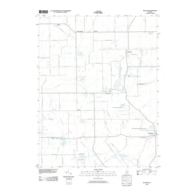
2010 Map of Blocher
USGS Topo · Published 2010About this map
Lexington serves as the primary hub in this portion of Scott County, where the road network converges near the Lexington Cemetery and the Presbyterian National Missions Lake. The landscape is defined by a dense system of waterways, including the winding Stucker Fork and Kimberlin Creek, which drain into several localized reservoirs such as Thomas J Miller Lake and Kinderhook Lake. Small settlements like Blocher, New Frankfort, and Goshen are connected by a grid of rural routes such as N Hardy Lake Rd and N Bethlehem Rd. Genealogists will find significant value in the distribution of family and community burial grounds, including the Bethel Cemetery, Hopewell Cemetery, and Owens Cemetery, which are tucked away along the various creek branches and farm lanes that characterize this agricultural region.
Find a feature on this map
75 named features on this map. Tap any name to fly to it.
Don’t see what you’re looking for? This feature index may not catch every label — zoom into the map to look around manually.
Map Details
Editions of this 2010 Blocher Map
This is the sole edition of this map. No revisions or reprints were ever made.
Other maps of this area

1947 · Scottsburg
USGS Topo · 1:24,000

1949 · Henryville
USGS Topo · 1:24,000

1956 · Otisco
USGS Topo · 1:24,000

1956 · Volga
USGS Topo · 1:24,000

1956 · Blocher
USGS Topo · 1:24,000

1956 · Kent
USGS Topo · 1:24,000

1956 · Deputy
USGS Topo · 1:24,000
1956 · New Washington
USGS Topo · 1:24,000

1956 · Louisville
USGS Topo · 1:250,000

1959 · Crothersville
USGS Topo · 1:24,000