
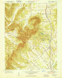
1949 Map of Henryville
USGS Topo · Published 1949About this map
Clark State Forest dominates much of this Southern Indiana landscape, illustrating the region's mid-century focus on timber management and conservation. The village of Henryville sits at the junction of several drainage systems, including Wolf Run and Guernsey Creek, while the Pennsylvania railroad line provides a critical transportation corridor through the eastern half of the quadrangle. High points like Lookout Ridge and the Bartle Knobs provide a dramatic backdrop to scattered rural settlements and agricultural clearings.
Find a feature on this map
45 named features on this map. Tap any name to fly to it.
Don’t see what you’re looking for? This feature index may not catch every label — zoom into the map to look around manually.
Map Details
Editions of this 1949 Henryville Map
2 editions found
Other maps of this area

1905 · Prospect
USGS Topo · 1:62,500

1912 · Prospect
USGS Topo · 1:62,500

1937 · Charlestown
USGS Topo · 1:24,000

1938 · Speed
USGS Topo · 1:24,000

1941 · Borden
USGS Topo · 1:24,000

1947 · Speed
USGS Topo · 1:24,000

1947 · Scottsburg
USGS Topo · 1:24,000
1950 · Charlestown
USGS Topo · 1:24,000

1955 · South Boston
USGS Topo · 1:24,000

1956 · Otisco
USGS Topo · 1:24,000