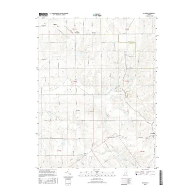
2016 Map of Blocher
USGS Topo · Published 2016About this map
Lexington serves as a primary settlement in this southeastern Indiana landscape, situated where the Jefferson Co and Scott Co border defines the eastern edge of the quadrangle. The terrain is characterized by a dense network of watercourses, notably Stucker Fork and Kimberlin Cr, which wind through the township. Small rural communities like Blocher, New Frankfort, and Wooster are connected by a grid of county roads and the arterial E State RD 256. Genealogy researchers will find several family and community burial sites, including Bethel Cem, Owens Cem, and Reeve Cem, situated near historic drainage features like Hopewell Drain. The distribution of residential clusters around water bodies such as Lake McCulloch and Smith Lake illustrates the local patterns of land use and modern settlement that have evolved around these central drainage basins.
Find a feature on this map
88 named features on this map. Tap any name to fly to it.
Don’t see what you’re looking for? This feature index may not catch every label — zoom into the map to look around manually.
Map Details
Editions of this 2016 Blocher Map
This is the sole edition of this map. No revisions or reprints were ever made.
Other maps of this area

1947 · Scottsburg
USGS Topo · 1:24,000

1949 · Henryville
USGS Topo · 1:24,000

1956 · Otisco
USGS Topo · 1:24,000

1956 · Volga
USGS Topo · 1:24,000

1956 · Blocher
USGS Topo · 1:24,000

1956 · Kent
USGS Topo · 1:24,000

1956 · Deputy
USGS Topo · 1:24,000
1956 · New Washington
USGS Topo · 1:24,000

1956 · Louisville
USGS Topo · 1:250,000

1959 · Crothersville
USGS Topo · 1:24,000