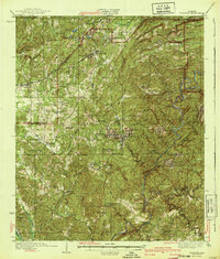
1940 Map of Blocton
USGS Topo · Published 1940About this map
West Blocton and the neighboring community of Blocton anchor this survey of the Alabama coal country, revealing a landscape defined by industrial extraction and rail transport. The Southern, Louisville and Nashville, and Mobile and Ohio railroads converge here, connecting settlements like Belle Ellen, Coleanor, and Piper to the broader regional economy. The rugged terrain is deeply etched by the Cahaba River and the Little Cahaba River, while the rural uplands are dotted with family-named landmarks and community institutions such as Mt Carmel Ch and Rock Institute Sch. One notable crossing, the Pratt Ferry Bridge, provides a vital link across the Cahaba in the southern reaches. The density of small schools and chapels, including Ada Chapel and Blue Grove Sch, reflects a dispersed but active population living amidst the ridges and creek valleys of Bibb County.
Find a feature on this map
69 named features on this map. Tap any name to fly to it.
Don’t see what you’re looking for? This feature index may not catch every label — zoom into the map to look around manually.
Map Details
Editions of this 1940 Blocton Map
2 editions found

Other maps of this area

1890 · Bessemer
USGS Topo · 1:125,000

1891 · Clanton
USGS Topo · 1:125,000

1892 · Bessemer
USGS Topo · 1:125,000

1899 · Brookwood
USGS Topo · 1:125,000

1905 · Bessemer Iron District
USGS Topo · 1:62,500

1907 · Bessemer Special
USGS Topo · 1:62,500

1910 · Montevallo
USGS Topo · 1:62,500

1927 · Adger
USGS Topo · 1:48,000

1929 · Searles
USGS Topo · 1:48,000

1931 · Cottondale
USGS Topo · 1:48,000