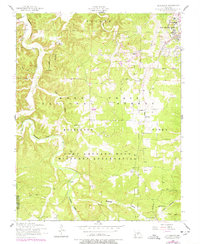
1954 Map of Bloodland
USGS Topo · Published 1977About this map
Roubidoux Creek meanders through this portion of the Ozarks, carving a deep valley that separates the Mark Twain National Forest from the high plateaus. The landscape is defined by its transition into a military-dominated area, as the Fort Leonard Wood Military Reservation encompasses significant territory south of the established Cullen and Roubidoux township lines. In the northeast, Forney Army Airfield stands as a center of activity with its Control Tower and Beacon near the airfield complex.
Find a feature on this map
31 named features on this map. Tap any name to fly to it.
Don’t see what you’re looking for? This feature index may not catch every label — zoom into the map to look around manually.
Map Details
Editions of this 1954 Bloodland Map
3 editions found
Other maps of this area

1936 · Waynesville
USGS Topo · 1:48,000

1941 · Big Piney
USGS Topo · 1:62,500

1942 · Waynesville
USGS Topo · 1:62,500

1943 · Richland
USGS Topo · 1:62,500

1943 · Big Piney
USGS Topo · 1:62,500

1943 · Drynob
USGS Topo · 1:62,500

1944 · Waynesville
USGS Topo · 1:62,500

1954 · Springfield
USGS Topo · 1:250,000

1954 · Drynob
USGS Topo · 1:62,500
1954 · Big Piney
USGS Topo · 1:62,500