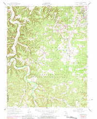
1954 Map of Bloodland
USGS Topo · Published 1984About this map
Fort Leonard Wood Military Reservation dominates the heart of this mid-century landscape, a terrain where government land use meets the older rural geography of the Missouri Ozarks. While the Mark Twain National Forest preserves the northern reaches, the map reveals the complex intersection of military infrastructure and established community centers. Settled pockets like Hanna and Cookville are interspersed among topographic features such as Berry Cave and Musgrave Hollow.
Find a feature on this map
29 named features on this map. Tap any name to fly to it.
Don’t see what you’re looking for? This feature index may not catch every label — zoom into the map to look around manually.
Map Details
Editions of this 1954 Bloodland Map
3 editions found
Other maps of this area

1936 · Waynesville
USGS Topo · 1:48,000

1941 · Big Piney
USGS Topo · 1:62,500

1942 · Waynesville
USGS Topo · 1:62,500

1943 · Richland
USGS Topo · 1:62,500

1943 · Big Piney
USGS Topo · 1:62,500

1943 · Drynob
USGS Topo · 1:62,500

1944 · Waynesville
USGS Topo · 1:62,500

1954 · Springfield
USGS Topo · 1:250,000

1954 · Drynob
USGS Topo · 1:62,500
1954 · Big Piney
USGS Topo · 1:62,500