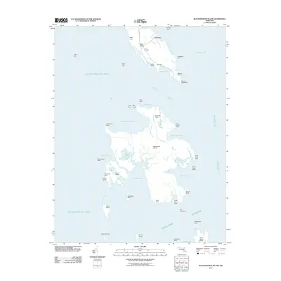
2011 Map of Bloodsworth Island
USGS Topo · Published 2011About this map
Bethany Cemetery sits near the small settlement of Crocheron at the northern tip of this aquatic landscape, marking a human foothold amidst the shifting marsh and tide. This survey of the lower Chesapeake Bay reveals a fragmented archipelago dominated by Bloodsworth Island, where complex waterways like Swan Pond Creek and Fin Creek carve through the land. The presence of Honga River Light and Hooper Strait Light underscores the navigational importance of these waters, which are defined by wide expanses like Fishing Bay and the Hooper Straits. To the south, isolated landmasses such as Holland Island and Adam Island stand as remnants of a larger coastal footprint, while the names of numerous points and coves like Okahanikan Point and Tigs Cove document a deeply historical maritime geography in Dorchester County.
Find a feature on this map
54 named features on this map. Tap any name to fly to it.
Don’t see what you’re looking for? This feature index may not catch every label — zoom into the map to look around manually.
Map Details
Editions of this 2011 Bloodsworth Island Map
This is the sole edition of this map. No revisions or reprints were ever made.
Other maps of this area

1898 · St. Marys
USGS Topo · 1:125,000

1903 · Nanticoke
USGS Topo · 1:62,500

1903 · Bloodsworth Island
USGS Topo · 1:62,500

1903 · Deal Island
USGS Topo · 1:62,500

1905 · Crapo
USGS Topo · 1:62,500

1906 · St. Marys
USGS Topo · 1:125,000

1942 · Terrapin Sand Point
USGS Topo · 1:24,000

1942 · Kedges Straits
USGS Topo · 1:24,000

1942 · Bloodsworth Island
USGS Topo · 1:24,000

1942 · Richland Point
USGS Topo · 1:24,000