
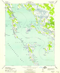
1942 Map of Bloodsworth Island
USGS Topo · Published 1957About this map
Bloodsworth Island and the surrounding marshlands of the Chesapeake Bay define this 1942 survey, showing the intricate network of guts, coves, and ridges before significant mid-century shoreline changes. The settlement of Crocheron stands as a focal point on the northern neck of Bishops Head, surrounded by the vast Bishops Head Marsh. This era of mapping, conducted by the Army Map Service, captures the maritime infrastructure essential to the region's watermen, including the Hooper Strait Lighthouse and the Honga River Light. The geography is characterized by fragmented landforms like Pone Island and Adam Island, separated from the main island by Okahanikan Cove and Pone Cove. These details offer a precise view of the Dorchester and Somerset County boundary as it follows the tidal channels of the Tangier Sound and Hooper Strait.
Find a feature on this map
65 named features on this map. Tap any name to fly to it.
Don’t see what you’re looking for? This feature index may not catch every label — zoom into the map to look around manually.
Map Details
Editions of this 1942 Bloodsworth Island Map
This is the sole edition of this map. No revisions or reprints were ever made.
Other maps of this area

1898 · St. Marys
USGS Topo · 1:125,000

1903 · Nanticoke
USGS Topo · 1:62,500

1903 · Bloodsworth Island
USGS Topo · 1:62,500

1903 · Deal Island
USGS Topo · 1:62,500

1905 · Crapo
USGS Topo · 1:62,500

1906 · St. Marys
USGS Topo · 1:125,000

1942 · Terrapin Sand Point
USGS Topo · 1:24,000

1942 · Kedges Straits
USGS Topo · 1:24,000

1942 · Richland Point
USGS Topo · 1:24,000
1942 · Honga
USGS Topo · 1:24,000