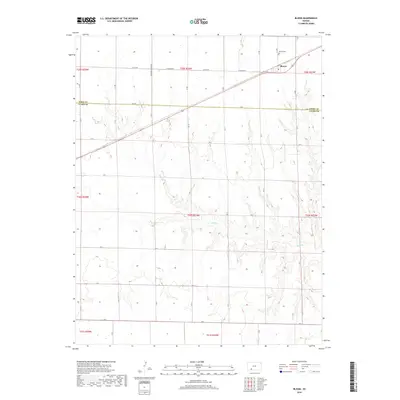
2018 Map of Bloom
USGS Topo · Published 2018About this map
Bloom sits at the northern edge of this high plains landscape, situated near the headwaters of Bluff Cr. The town is the primary settlement on the map, centered around the intersection of K C H Rd and Highway 54. Just to the north, the Bloom Cem serves as a vital marker for genealogists and local historians tracing families from this corner of Ford County. The terrain is defined by the drainage patterns of Bluff Cr, which carves a path through the township sections as it flows southward across the Ford Co Clark Co line. A grid of rural roads like Yucca Rd and Zane Rd provides structure to the open agricultural land, illustrating the persistent section-line development typical of western Kansas. The map captures the quiet, expansive nature of the region, where settlement is concentrated along the rail and highway corridor while the rest of the land remains dedicated to the drainage of the creek.
Find a feature on this map
23 named features on this map. Tap any name to fly to it.
Don’t see what you’re looking for? This feature index may not catch every label — zoom into the map to look around manually.
Map Details
Editions of this 2018 Bloom Map
This is the sole edition of this map. No revisions or reprints were ever made.
Other maps of this area

1892 · Meade
USGS Topo · 1:125,000

1892 · Dodge
USGS Topo · 1:125,000

1892 · Spearville
USGS Topo · 1:125,000

1894 · Spearville
USGS Topo · 1:125,000

1896 · Ashland
USGS Topo · 1:125,000

1955 · Pratt
USGS Topo · 1:250,000

1955 · Dodge City
USGS Topo · 1:250,000

1958 · Dodge City
USGS Topo · 1:250,000

1959 · Pratt
USGS Topo · 1:250,000

1959 · Dodge City
USGS Topo · 1:250,000