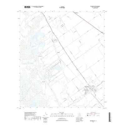
2019 Map of Bloomington
USGS Topo · Published 2019About this map
The Guadalupe River meanders through this portion of Victoria County, shaping a landscape defined by expansive wetlands and industrial water management. This area is anchored by Bloomington, where a grid of residential streets like Sherley St and Diesel Dr meets the regional transport lines of 185 and FM 404. The river valley features complex drainage patterns including Blue Bayou, Spring Bayou, and Black Bayou, alongside man-made alterations such as the Dupont Cooling Basin and the Lipscomb and Son Reservoir. Smaller settlements like Dernal and Dacosta are situated along the primary roadways, while the San Jose Cem and Dalton Bridge serve as specific landmarks for local history and genealogy. The map reveals the intersection of the natural coastal prairie environment with late-twentieth-century industrial and agricultural infrastructure.
Find a feature on this map
83 named features on this map. Tap any name to fly to it.
Don’t see what you’re looking for? This feature index may not catch every label — zoom into the map to look around manually.
Map Details
Editions of this 2019 Bloomington Map
This is the sole edition of this map. No revisions or reprints were ever made.
Other maps of this area

1951 · Bloomington
USGS Topo · 1:24,000

1952 · Bloomington SW
USGS Topo · 1:24,000

1952 · Marcado Creek
USGS Topo · 1:24,000

1952 · Placedo
USGS Topo · 1:24,000

1952 · Victoria East
USGS Topo · 1:24,000

1952 · Green Lake
USGS Topo · 1:24,000

1953 · Beeville
USGS Topo · 1:250,000

1956 · Beeville
USGS Topo · 1:250,000

1960 · Beeville
USGS Topo · 1:250,000

1962 · McFaddin
USGS Topo · 1:24,000