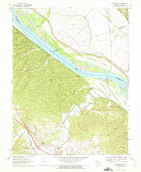
1970 Map of Bloomsdale
USGS Topo · Published 1972About this map
The Mississippi River cuts a wide swath through this borderland between Missouri and Illinois, separating the dense network of ravines in Ste Genevieve County from the flat bottomlands of the northeast. This 1970s landscape is defined by its deep hollows, such as Jackson Hollow and Wolf Hollow, which drain toward the river via Establishment Creek and Pourche a Du Clos. The community of Bloomsdale sits near the southern edge of the sheet, served by the Bloomsdale Sch, while the riverfront history is anchored by Fort Chartres State Park across the water. Transport corridors like the St Louis San Francisco railroad and the Missouri Pacific line trace the river’s path, connecting small riverfront settlements like Clement and Kidd. Numerous active and historical Quarries dot the bluffs near Needmore, pointing to the region's extraction industries.
Find a feature on this map
36 named features on this map. Tap any name to fly to it.
Don’t see what you’re looking for? This feature index may not catch every label — zoom into the map to look around manually.
Map Details
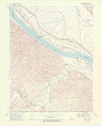
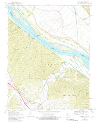
Editions of this 1970 Bloomsdale Map
3 editions found
Other maps of this area

1904 · Farmington
USGS Topo · 1:62,500

1906 · Farmington
USGS Topo · 1:62,500

1907 · Weingarten
USGS Topo · 1:62,500

1909 · Weingarten
USGS Topo · 1:62,500

1915 · Renault
USGS Topo · 1:62,500

1915 · Crystal City
USGS Topo · 1:62,500

1940 · Renault
USGS Topo · 1:62,500

1949 · Saint Louis
USGS Topo · 1:250,000

1949 · Rolla
USGS Topo · 1:250,000
1949 · Crystal City
USGS Topo · 1:62,500