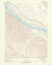
1970 Map of Bloomsdale
USGS Topo · Published 1972About this map
The Mississippi River serves as the focal point of this 1970s landscape, marking the boundary between Illinois and Missouri as it winds past Fort Chartres State Park. On the Missouri side, the St Louis San Francisco railroad follows the river's edge, connecting the riverfront settlements of Brickeys and Clement. The terrain here is deeply carved by numerous drainages, most notably Establishment Creek and the Fourche a Du Clos, which flow through a network of family-named hollows like Magnolia Hollow and Staples Hollow.
Find a feature on this map
35 named features on this map. Tap any name to fly to it.
Don’t see what you’re looking for? This feature index may not catch every label — zoom into the map to look around manually.
Map Details
Editions of this 1970 Bloomsdale Map
3 editions found
Other maps of this area

1904 · Farmington
USGS Topo · 1:62,500

1906 · Farmington
USGS Topo · 1:62,500

1907 · Weingarten
USGS Topo · 1:62,500

1909 · Weingarten
USGS Topo · 1:62,500

1915 · Renault
USGS Topo · 1:62,500

1915 · Crystal City
USGS Topo · 1:62,500

1940 · Renault
USGS Topo · 1:62,500

1949 · Saint Louis
USGS Topo · 1:250,000

1949 · Rolla
USGS Topo · 1:250,000

1949 · Crystal City
USGS Topo · 1:62,500