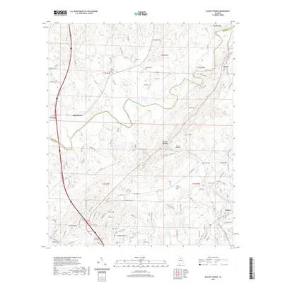
2020 Map of Blount Springs
USGS Topo · Published 2020About this map
The Mulberry Fork snakes through the center of this landscape, marking the boundary where Cullman and Blount counties meet. The historic community of Blount Springs is situated along the narrow valley floor, flanked by Duffy Mtn and Huffman Mtn. This area is defined by its transit history, following the CSX Transportation rail corridor as it pierces the high ridges through the Blount Tunnel and Hayden Tunnel. Local genealogy is well-preserved through numerous family and community burial grounds, including the Moore Cem near the springs and the Cedar Grove Cem further south.
Find a feature on this map
140 named features on this map. Tap any name to fly to it.
Don’t see what you’re looking for? This feature index may not catch every label — zoom into the map to look around manually.
Map Details
Editions of this 2020 Blount Springs Map
This is the sole edition of this map. No revisions or reprints were ever made.
Other maps of this area

1888 · Cullman
USGS Topo · 1:125,000

1889 · Birmingham
USGS Topo · 1:125,000

1892 · Cullman
USGS Topo · 1:125,000

1892 · Birmingham
USGS Topo · 1:125,000

1895 · Birmingham
USGS Topo · 1:125,000

1907 · Birmingham
USGS Topo · 1:125,000

1951 · Arkadelphia
USGS Topo · 1:24,000

1951 · Warrior
USGS Topo · 1:24,000
1951 · Creel
USGS Topo · 1:24,000

1951 · Blount Springs
USGS Topo · 1:24,000