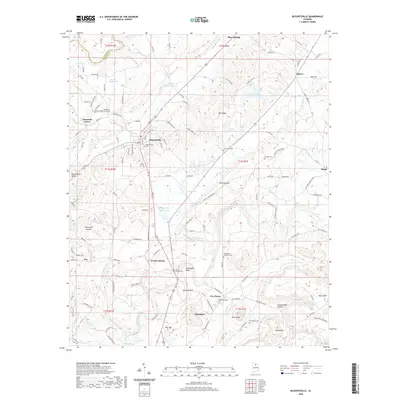
2020 Map of Blountsville
USGS Topo · Published 2020About this map
Blountsville sits at the heart of this North Alabama landscape, where the ridges of the Appalachian foothills guide the local drainage and road networks. The town's historical footprint is anchored by the Blountsville Cem, while the surrounding rural landscape is dotted with smaller communities such as Mountain Grove, Liberty, and Cleveland. The terrain is defined by the parallel paths of the Locust Fork and the Mulberry Fork, which carve through the plateau and create distinct topographic features like Hamilton Mtn and Mid Ridge. This modern survey illustrates the persistent rural character of Blount County, showing how established family-named landmarks and cemeteries like Graves Cem and Oak Grove Cem continue to define the community's geography. Scattered ponds and small lakes, including Osborne Lake and Burgess Spring Lakes, underscore the importance of local water resources in this well-watered upland region.
Find a feature on this map
133 named features on this map. Tap any name to fly to it.
Don’t see what you’re looking for? This feature index may not catch every label — zoom into the map to look around manually.
Map Details
Editions of this 2020 Blountsville Map
This is the sole edition of this map. No revisions or reprints were ever made.
Other maps of this area

1885 · Gadsden
USGS Topo · 1:125,000

1888 · Cullman
USGS Topo · 1:125,000

1888 · Gadsden
USGS Topo · 1:125,000

1889 · Springville
USGS Topo · 1:125,000

1889 · Birmingham
USGS Topo · 1:125,000

1892 · Cullman
USGS Topo · 1:125,000

1892 · Birmingham
USGS Topo · 1:125,000

1892 · Springville
USGS Topo · 1:125,000

1892 · Gadsden
USGS Topo · 1:125,000

1895 · Gadsden
USGS Topo · 1:125,000