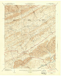
1939 Map of Blountville
USGS Topo · Published 1939About this map
Blountville serves as the focal point of this late 1930s survey, showing the community just before the rapid post-war changes in East Tennessee. The town center is clearly marked by the Court House, while the surrounding landscape is defined by a dense network of country schools and churches that speak to the rural social structure of Sullivan County. Landmarks like the County Farm and Fraley Institute provide a glimpse into the civic and educational institutions of the era.
Find a feature on this map
51 named features on this map. Tap any name to fly to it.
Don’t see what you’re looking for? This feature index may not catch every label — zoom into the map to look around manually.
Map Details
Editions of this 1939 Blountville Map
2 editions found
Other maps of this area

1891 · Roan Mountain
USGS Topo · 1:125,000

1894 · Roan Mountain
USGS Topo · 1:125,000

1897 · Bristol
USGS Topo · 1:125,000

1902 · Bristol
USGS Topo · 1:125,000

1904 · Roan Mountain
USGS Topo · 1:125,000

1934 · Wallace
USGS Topo · 1:24,000

1934 · Bristol
USGS Topo · 1:24,000

1935 · Hilton
USGS Topo · 1:24,000

1935 · Watauga Valley
USGS Topo · 1:48,000

1935 · Mendota
USGS Topo · 1:24,000