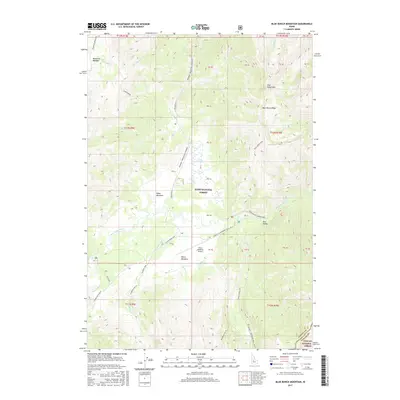
2017 Map of Blue Bunch Mountain
USGS Topo · Published 2017About this map
Bruce Meadows Airport serves as a remote aviation hub within the expansive Boise National Forest of Valley County, where high-elevation drainage systems define the landscape. This 2017 survey details the complex hydrography of the Salmon River mountains, anchored by the significant Dagger Falls and the confluence of numerous mountain streams like Bear Valley Creek and Boundary Cr. The area is characterized by several high-mountain meadows including Poker Meadows, Ayers Meadows, and Mountain Meadow, which likely served as seasonal grazing or recreation sites. Historical and modern transportation routes are well-documented, from the established Boundary Creek Road Corridor to the winding Stanley-Landmark Trail and the Wyoming-Fir Cr route. The map also delineates the jurisdictional transition along the eastern edge where the forest meets the Challis National Forest at the Custer County line.
Find a feature on this map
53 named features on this map. Tap any name to fly to it.
Don’t see what you’re looking for? This feature index may not catch every label — zoom into the map to look around manually.
Map Details
Editions of this 2017 Blue Bunch Mountain Map
This is the sole edition of this map. No revisions or reprints were ever made.
Other maps of this area

1891 · Bear Valley
USGS Topo · 1:125,000

1893 · Bear Valley
USGS Topo · 1:125,000

1957 · Challis
USGS Topo · 1:250,000

1960 · Challis
USGS Topo · 1:250,000

1961 · Greyhound Ridge
USGS Topo · 1:62,500

1961 · Chinook Mtn
USGS Topo · 1:62,500

1963 · Challis
USGS Topo · 1:250,000

1972 · Bull Trout Point
USGS Topo · 1:24,000
1972 · Banner Summit
USGS Topo · 1:24,000

1972 · Cache Creek
USGS Topo · 1:24,000