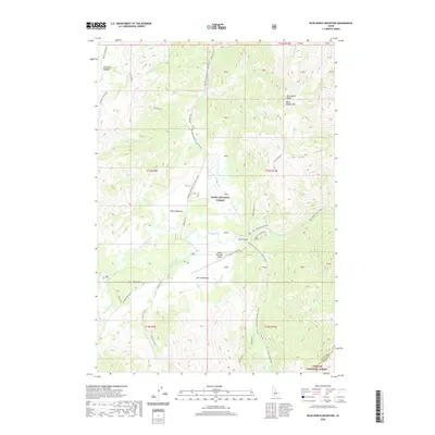
2020 Map of Blue Bunch Mountain
USGS Topo · Published 2020About this map
Bruce Meadows Airport serves as a distinct landmark within this high-elevation landscape where the Boise National Forest meets the Challis National Forest. This 2020 survey documents a complex network of seasonal corridors, including the Boundary Creek Road Corridor (Snow) and the Stanley-Landmark Trail, Rd #1 (Snow), reflecting the area's specialized backcountry access. The terrain is defined by broad meadows and significant water features, most notably Dagger Falls and the winding course of Bear Valley Creek. Geographers and local historians can trace the intersection of old trails and modern forest roads, such as the Stanley-Warm Lake Rd and the Lowman-Bear Valley Rd, which provide passage through the drainage systems of Wyoming Cr and Fir Cr near the Fir Creek Campground.
Find a feature on this map
42 named features on this map. Tap any name to fly to it.
Don’t see what you’re looking for? This feature index may not catch every label — zoom into the map to look around manually.
Map Details
Editions of this 2020 Blue Bunch Mountain Map
This is the sole edition of this map. No revisions or reprints were ever made.
Other maps of this area

1891 · Bear Valley
USGS Topo · 1:125,000

1893 · Bear Valley
USGS Topo · 1:125,000

1957 · Challis
USGS Topo · 1:250,000

1960 · Challis
USGS Topo · 1:250,000

1961 · Greyhound Ridge
USGS Topo · 1:62,500

1961 · Chinook Mtn
USGS Topo · 1:62,500

1963 · Challis
USGS Topo · 1:250,000

1972 · Bull Trout Point
USGS Topo · 1:24,000
1972 · Banner Summit
USGS Topo · 1:24,000

1972 · Cache Creek
USGS Topo · 1:24,000