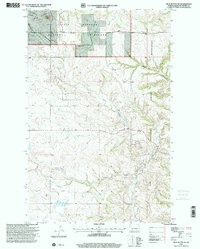
1997 Map of Blue Buttes SE
USGS Topo · Published 2001About this map
Little Missouri National Grassland dominates the northern reaches of this McKenzie County landscape, where the high plateaus of the Blue Buttes and Aura Butte rise above the drainage networks of Bear Den and Handy creek. This 1997 revision by the Forest Service captures a remote ranching and reservation landscape at the end of the century. To the east, the boundary of the Fort Berthold Indian Reservation is clearly delineated as it cuts across Foreman Coulee. Local land use is characterized by isolated homesteads and ranching operations like the C Mercer Ranch, alongside the namesake properties of D Sivertson and K Berg. The presence of a Scoria Pit in the southeast quadrant indicates the region's geological and small-scale extractive activity amidst the grazing lands.
Find a feature on this map
15 named features on this map. Tap any name to fly to it.
Don’t see what you’re looking for? This feature index may not catch every label — zoom into the map to look around manually.
Map Details
Editions of this 1997 Blue Buttes SE Map
This is the sole edition of this map. No revisions or reprints were ever made.
Other maps of this area

1953 · Watford City
USGS Topo · 1:250,000

1957 · Watford City
USGS Topo · 1:250,000

1959 · Croff
USGS Topo · 1:24,000

1965 · Keene
USGS Topo · 1:24,000

1965 · Johnsons Corner
USGS Topo · 1:24,000

1965 · Blue Buttes
USGS Topo · 1:24,000

1965 · Blue Buttes SE
USGS Topo · 1:24,000

1967 · Watford City
USGS Topo · 1:250,000

1967 · Sanish NW
USGS Topo · 1:24,000

1967 · Sanish SW
USGS Topo · 1:24,000