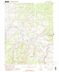
1985 Map of Blue Chief Mesa
USGS Topo · Published 1986About this map
The Dolores River cuts a deep, winding path through this corner of Grand County, Utah, creating a landscape defined by towering plateaus and canyon floors. Along the river banks, Utah Bottoms represents a rare stretch of relatively level ground, while a solitary Gaging Station and a single Bridge mark the limited points of human utility along the water. The surrounding high ground, including Buckhorn Mesa and Blue Chief Mesa, contains evidence of mid-20th-century mineral exploration. Scattered across the mesas and canyons like Cottonwood Canyon are numerous Prospects, Adits, and even a documented Mine Shaft, signaling the region's history of uranium and vanadium prospecting. This 1980s-era field check documents the intersection of this industrial exploration with the complex drainage systems of Buckhorn Draw and Granite Creek.
Find a feature on this map
20 named features on this map. Tap any name to fly to it.
Don’t see what you’re looking for? This feature index may not catch every label — zoom into the map to look around manually.
Map Details
Editions of this 1985 Blue Chief Mesa Map
This is the sole edition of this map. No revisions or reprints were ever made.
Other maps of this area

1885 · La Sal
USGS Topo · 1:250,000

1954 · Mt. Waas 4 NE
USGS Topo · 1:24,000

1954 · Mt. Waas 4 NW
USGS Topo · 1:24,000

1954 · Mt. Waas 3 NE
USGS Topo · 1:24,000

1954 · Mt. Waas 1 SW
USGS Topo · 1:24,000

1954 · Mt. Waas 1 NE
USGS Topo · 1:24,000

1954 · Mt. Waas 1 NW
USGS Topo · 1:24,000

1954 · Mt. Waas 1 SE
USGS Topo · 1:24,000

1954 · Coates Creek
USGS Topo · 1:62,500

1954 · Polar Mesa
USGS Topo · 1:62,500