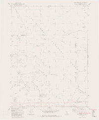
1982 Map of Blue Creek Mtn
USGS Topo · Published 1982About this map
Six Rivers National Forest dominates this topographic study of the California wilderness in the early 1980s. The landscape is defined by the complex drainage systems of Blue Creek and Pecwan Creek, which carve through the high elevations of the Klamath Mountains. Notable landmarks such as Blue Creek Mtn, Nickowitz Peak, and Barren Butte rise above the deep canyons, illustrating the verticality of this remote timber and conservation land. The presence of Stevens Prairie and Bear Pen Flat suggests pockets of open terrain amidst the dense forest, while the boundary between Del Norte and Humboldt counties bisects the quadrangle. A few secondary access points are noted, including Lookout Point and several 4WD tracks, which provide the only human-made transit across these ridges.
Find a feature on this map
29 named features on this map. Tap any name to fly to it.
Don’t see what you’re looking for? This feature index may not catch every label — zoom into the map to look around manually.
Map Details
Editions of this 1982 Blue Creek Mtn Map
2 editions found
Other maps of this area

1922 · Preston Peak
USGS Topo · 1:125,000

1925 · Hoopa
USGS Topo · 1:125,000

1945 · Ship Mountain
USGS Topo · 1:62,500

1945 · Tectah Creek
USGS Topo · 1:62,500

1948 · Weed
USGS Topo · 1:250,000

1950 · Weed
USGS Topo · 1:250,000

1952 · Ship Mountain
USGS Topo · 1:62,500

1952 · Orleans
USGS Topo · 1:62,500

1952 · Tectah Creek
USGS Topo · 1:62,500

1955 · Dillon Mtn
USGS Topo · 1:62,500