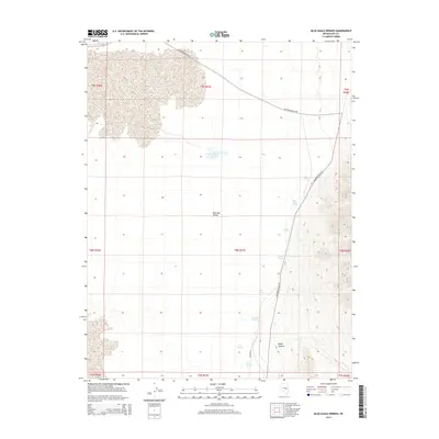
2014 Map of Blue Eagle Springs
USGS Topo · Published 2014About this map
Railroad Valley dominates this high-desert landscape in Nye County, where water is the primary catalyst for both settlement and survival. The map documents a critical chain of water sources along the eastern edge of the valley floor, including Blue Eagle Springs, Butterfield Springs, and Soda Spring. These desert seeps and Blue Eagle Ponds provide a vital network for land use in an otherwise arid basin. Infrastructure is focused on historic transit corridors, notably the Midland Trl and Railroad Valley Rd, which skirt the alluvial fans beneath the mountains. To the southeast, the terrain rises into the mouth of Beaty Canyon, illustrating the transition from flat valley bottom to the steep, drainage-cut slopes that define the region's topography.
Find a feature on this map
22 named features on this map. Tap any name to fly to it.
Don’t see what you’re looking for? This feature index may not catch every label — zoom into the map to look around manually.
Map Details
Editions of this 2014 Blue Eagle Springs Map
This is the sole edition of this map. No revisions or reprints were ever made.
Other maps of this area

1956 · Lund
USGS Topo · 1:250,000

1960 · Lund
USGS Topo · 1:250,000

1964 · Blue Eagle Springs
USGS Topo · 1:62,500

1964 · Currant
USGS Topo · 1:62,500

1964 · Troy Canyon
USGS Topo · 1:62,500

1964 · Forest Home
USGS Topo · 1:62,500

1980 · Duckwater
USGS Topo · 1:100,000

1988 · Quinn Canyon Range
USGS Topo · 1:100,000
1990 · Currant
USGS Topo · 1:24,000
1990 · Meteorite Crater
USGS Topo · 1:24,000