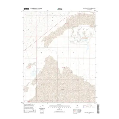
2015 Map of Blue Eagle Springs SW
USGS Topo · Published 2015About this map
Butterfield Marsh dominates the southern reaches of this landscape, marking a significant hydrologic feature in the arid environment of Nye County. The area is characterized by scattered water sources that would have been vital for livestock and early travel through the Great Basin. To the north, Big Well Ponds provides another localized water point, while Lockes Ponds sits further west. These features reflect the sparse but critical water network common in the basin and range province, where life and transit were historically dictated by the location of springs and marshes. This 2015 update, produced by the U.S. Geological Survey, uses high-resolution data to delineate the boundaries of these wetlands and the surrounding public land survey system divisions, including t8n r56e and t9n r56e.
Find a feature on this map
9 named features on this map. Tap any name to fly to it.
Don’t see what you’re looking for? This feature index may not catch every label — zoom into the map to look around manually.
Map Details
Editions of this 2015 Blue Eagle Springs SW Map
This is the sole edition of this map. No revisions or reprints were ever made.
Other maps of this area

1956 · Lund
USGS Topo · 1:250,000

1960 · Lund
USGS Topo · 1:250,000

1964 · Blue Eagle Springs
USGS Topo · 1:62,500

1964 · Troy Canyon
USGS Topo · 1:62,500

1968 · Portuguese Mtn
USGS Topo · 1:62,500

1968 · The Wall
USGS Topo · 1:62,500

1968 · Portuguese Mtn
USGS Topo · 1:24,000
1968 · Lockes
USGS Topo · 1:24,000
1968 · The Wall NE
USGS Topo · 1:24,000

1980 · Duckwater
USGS Topo · 1:100,000