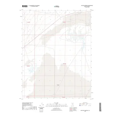
2018 Map of Blue Eagle Springs SW
USGS Topo · Published 2018About this map
Butterfield Marsh dominates the southern half of this landscape in Nye County, creating an extensive wetland complex within the Great Basin's arid environment. The map highlights the delicate hydrology of the region, where internal drainage basins collect seasonal runoff. To the north, the terrain transitions toward the Big Well Ponds, another localized water feature that underscores the vital importance of surface water in this high-desert territory. Surveyed by the U.S. Geological Survey, the sheet documents the Public Land Survey System grid across multiple townships, including t8n r56e and t9n r56e. These boundaries and water features illustrate the traditional land divisions and the natural constraints that have shaped Nevada's interior ranching and resource management history.
Find a feature on this map
8 named features on this map. Tap any name to fly to it.
Don’t see what you’re looking for? This feature index may not catch every label — zoom into the map to look around manually.
Map Details
Editions of this 2018 Blue Eagle Springs SW Map
This is the sole edition of this map. No revisions or reprints were ever made.
Other maps of this area

1956 · Lund
USGS Topo · 1:250,000

1960 · Lund
USGS Topo · 1:250,000

1964 · Blue Eagle Springs
USGS Topo · 1:62,500

1964 · Troy Canyon
USGS Topo · 1:62,500

1968 · Portuguese Mtn
USGS Topo · 1:62,500

1968 · The Wall
USGS Topo · 1:62,500

1968 · Portuguese Mtn
USGS Topo · 1:24,000
1968 · Lockes
USGS Topo · 1:24,000
1968 · The Wall NE
USGS Topo · 1:24,000

1980 · Duckwater
USGS Topo · 1:100,000