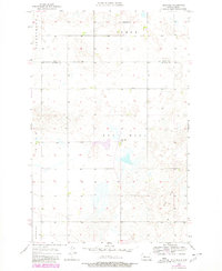
1956 Map of Blue Hill
USGS Topo · Published 1980About this map
Blue Hill and the surrounding high plains of the Missouri Plateau define this landscape along the border of Ward Co and Mc Lean Co. This 1956 survey, later updated with photorevised data in 1980, captures the rural educational infrastructure of mid-century North Dakota, highlighting the Blue Hill Sch and Centerville Sch which served the dispersed farming community. The terrain is marked by distinctive topographic features such as Hiddenwood and Gate, showing the complex drainage and elevation patterns of the region.
Find a feature on this map
8 named features on this map. Tap any name to fly to it.
Don’t see what you’re looking for? This feature index may not catch every label — zoom into the map to look around manually.
Map Details
Editions of this 1956 Blue Hill Map
2 editions found
Other maps of this area

1954 · McClusky
USGS Topo · 1:250,000

1956 · Emmet NE
USGS Topo · 1:24,000

1956 · Blackwater Lake
USGS Topo · 1:24,000

1956 · Blue Hill
USGS Topo · 1:24,000

1956 · Emmet
USGS Topo · 1:24,000

1956 · Douglas West
USGS Topo · 1:24,000

1956 · Roseglen
USGS Topo · 1:24,000

1958 · McClusky
USGS Topo · 1:250,000

1980 · Lake Vernon
USGS Topo · 1:24,000

1980 · Makoti
USGS Topo · 1:24,000