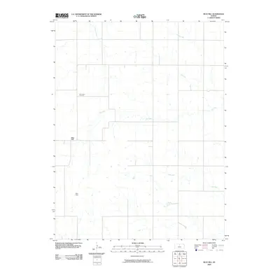
2009 Map of Blue Hill
USGS Topo · Published 2009About this map
Rose Valley Cemetery sits in the northern reaches of this Mitchell County landscape, a vital point of reference for genealogists tracking early settlers in this rural expanse. The terrain is characterized by the prominent elevation of the Blue Hills, which rise above a complex network of drainage basins. The hydrologic pattern is defined by several significant watercourses, including the westward-flowing Salt Creek and numerous tributaries such as Walnut Creek, Antelope Creek, and Cole Creek. The small community of Blue Hill serves as a central landmark amidst the section-line roads that organize the agricultural territory. This survey reflects the enduring rural structure of North Central Kansas at the start of the twenty-first century, showing the intersection of natural topography and established land divisions.
Find a feature on this map
8 named features on this map. Tap any name to fly to it.
Don’t see what you’re looking for? This feature index may not catch every label — zoom into the map to look around manually.
Map Details
Editions of this 2009 Blue Hill Map
This is the sole edition of this map. No revisions or reprints were ever made.
Other maps of this area

1894 · Beloit
USGS Topo · 1:125,000

1953 · Solomon Rapids
USGS Topo · 1:24,000

1953 · Waconda Springs
USGS Topo · 1:24,000

1953 · Glen Elder South
USGS Topo · 1:24,000

1955 · Beloit
USGS Topo · 1:250,000

1959 · Beloit
USGS Topo · 1:250,000

1967 · Hunter
USGS Topo · 1:24,000

1968 · Beloit SW
USGS Topo · 1:24,000

1968 · Lincoln NW
USGS Topo · 1:24,000
1968 · Ash Grove
USGS Topo · 1:24,000