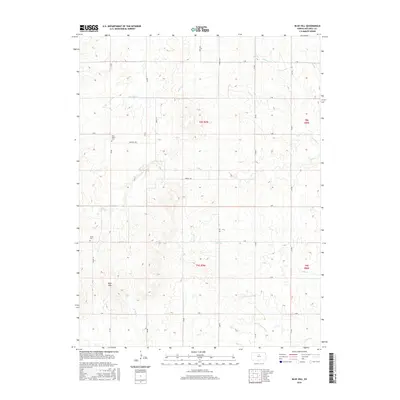
2015 Map of Blue Hill
USGS Topo · Published 2015About this map
The Blue Hills rise prominently in the southwestern portion of this Mitchell County landscape, punctuating an otherwise rhythmic series of prairie draws and drainages. The area is defined by its deep agricultural grid and the various waterways that cut through the rolling elevation, including the winding courses of Antelope Cr and Walnut Cr. A network of rural section roads, such as Robert Trl and Quinton Trl, connects the isolated farmsteads that occupy this portion of north-central Kansas. For those tracing family history or local settlement patterns, the location of early rural burial sites is key. The map clearly identifies Rose Valley Cem in the northwest and Union Cem near the western edge, providing concrete points of reference for genealogical research within these townships. The drainage patterns of Salt Cr and Little Cr further illustrate the natural hydrology that dictated early land use and settlement placement.
Find a feature on this map
31 named features on this map. Tap any name to fly to it.
Don’t see what you’re looking for? This feature index may not catch every label — zoom into the map to look around manually.
Map Details
Editions of this 2015 Blue Hill Map
This is the sole edition of this map. No revisions or reprints were ever made.
Other maps of this area

1894 · Beloit
USGS Topo · 1:125,000

1953 · Solomon Rapids
USGS Topo · 1:24,000

1953 · Waconda Springs
USGS Topo · 1:24,000

1953 · Glen Elder South
USGS Topo · 1:24,000

1955 · Beloit
USGS Topo · 1:250,000

1959 · Beloit
USGS Topo · 1:250,000

1967 · Hunter
USGS Topo · 1:24,000

1968 · Beloit SW
USGS Topo · 1:24,000

1968 · Lincoln NW
USGS Topo · 1:24,000
1968 · Ash Grove
USGS Topo · 1:24,000