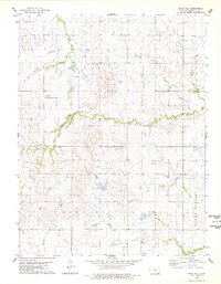
1978 Map of Blue Hill
USGS Topo · Published 1979About this map
Salt Creek winds through this rural Kansas landscape, providing a primary drainage route for the surrounding uplands of Mitchell County. The map documents the scattered settlement patterns of the late 1970s, centering on the small community of Blue Hill. The topography is defined by the Blue Hills and the Hayes township area, where the terrain shifts from relatively level plains to dissected drainages. Local landmarks like Rose Valley Cem and the Gravel Pits southwest of the settlement offer specific points of interest for genealogists and local historians tracking family homesteads. The intricate network of waterways, including Walnut Creek, Antelope Creek, Cole Creek, and Little Rock Creek, illustrates the natural irrigation and erosion patterns that have shaped the agricultural development of this north-central Kansas region.
Find a feature on this map
13 named features on this map. Tap any name to fly to it.
Don’t see what you’re looking for? This feature index may not catch every label — zoom into the map to look around manually.
Map Details
Editions of this 1978 Blue Hill Map
This is the sole edition of this map. No revisions or reprints were ever made.
Other maps of this area

1894 · Beloit
USGS Topo · 1:125,000

1953 · Solomon Rapids
USGS Topo · 1:24,000

1953 · Waconda Springs
USGS Topo · 1:24,000

1953 · Glen Elder South
USGS Topo · 1:24,000

1955 · Beloit
USGS Topo · 1:250,000

1959 · Beloit
USGS Topo · 1:250,000

1967 · Hunter
USGS Topo · 1:24,000

1968 · Beloit SW
USGS Topo · 1:24,000

1968 · Lincoln NW
USGS Topo · 1:24,000
1968 · Ash Grove
USGS Topo · 1:24,000