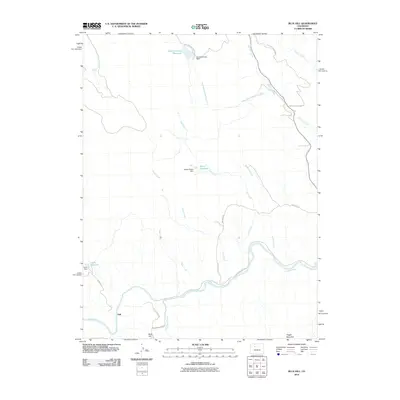
2010 Map of Blue Hill
USGS Topo · Published 2010About this map
The Colorado River winds through the southern reaches of this landscape near the settlement of Dell, where the Colorado River Rd and Castle Creek Rd parallel the water's edge. This high-country drainage system is defined by a network of seasonal and perennial streams including Tepee Creek, Stifel Creek, and Elk Creek, which feed into several small-scale irrigation and storage projects. Man-made features such as the Wohler-Waller Dam at Waller Reservoir and the Grimes-Brooks Dam at Grimes Brooks Reservoir reflect the water management essential to this part of Eagle County. Elevations range from the river valley up toward Blue Hill and the prominent Pisgah Mountain to the southeast. The area is intersected by several Bureau of Land Management routes, most notably the BLM King Mountain Rd, which provides access to the high ridges overlooking Egeria Creek and Red Dirt Creek.
Find a feature on this map
25 named features on this map. Tap any name to fly to it.
Don’t see what you’re looking for? This feature index may not catch every label — zoom into the map to look around manually.
Map Details
Editions of this 2010 Blue Hill Map
This is the sole edition of this map. No revisions or reprints were ever made.
Other maps of this area

1954 · Craig
USGS Topo · 1:250,000

1956 · Gore Pass
USGS Topo · 1:62,500

1957 · Craig
USGS Topo · 1:250,000

1957 · Leadville
USGS Topo · 1:250,000

1958 · Craig
USGS Topo · 1:250,000

1959 · Leadville
USGS Topo · 1:250,000

1960 · Leadville
USGS Topo · 1:250,000

1960 · Craig
USGS Topo · 1:250,000

1962 · Leadville
USGS Topo · 1:250,000

1962 · Craig
USGS Topo · 1:250,000