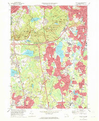
1971 Map of Blue Hills
USGS Topo · Published 1972About this map
The Blue Hills reservation and its surrounding suburban centers in Norfolk County are documented here during a period of significant highway development. The landscape is defined by the high ground of Great Blue Hill, where the Observatory and Radio Towers (WGBH) stand as regional landmarks. This terrain transitions into the densely settled neighborhoods of Quincy, Milton, and Braintree, which are bisected by the Southeast Expressway. In the southern half of the map, the industrial and residential growth of Randolph, Holbrook, and Stoughton is evident, while the tracks of the Penn Central railroad maintain their historic corridors through these towns. Educational and religious institutions are prominent throughout the area, from Thayer Academy in Braintree to St Columbkilles Seminary near Milton. The presence of numerous Quarries and Gravel Pits reflects the area's geological legacy of stone extraction, particularly around South Quincy.
Find a feature on this map
152 named features on this map. Tap any name to fly to it.
Don’t see what you’re looking for? This feature index may not catch every label — zoom into the map to look around manually.
Map Details
Editions of this 1971 Blue Hills Map
2 editions found
Other maps of this area

1885 · Abington
USGS Topo · 1:62,500

1886 · Dedham
USGS Topo · 1:62,500

1888 · Abington
USGS Topo · 1:62,500

1892 · Boston Bay
USGS Topo · 1:62,500

1893 · Abington
USGS Topo · 1:62,500

1893 · Boston
USGS Topo · 1:62,500

1894 · Dedham
USGS Topo · 1:62,500

1903 · Boston
USGS Topo · 1:62,500

1903 · Boston Bay
USGS Topo · 1:62,500

1919 · Dedham
USGS Topo · 1:62,500