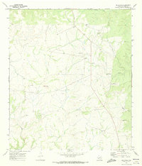
1970 Map of Blue Hills
USGS Topo · Published 1973About this map
Isolated cattle operations and rugged West Texas terrain define this 1970 snapshot of Val Verde County. Family holdings such as Albers Ranch, Quinn Ranch, and Mayfield Ranch are the primary points of human settlement, connected by unimproved roads and specialized infrastructure like the Landing Strips situated near the Albers property. The landscape is carved by deep drainage systems including Wallace Canyon, Sycamore Canyon, and Lewis Canyon, which funnel toward the Rio Grande drainage south of this area. Evidence of resource exploration and utility appears in the form of a Drill Hole and multiple Water Tank labels, which were essential for maintaining livestock in this arid environment. The eponymous Blue Hills rise as a central landmark, providing a rare topographic anchor in a territory marked by winding draws and limestone plateaus.
Find a feature on this map
13 named features on this map. Tap any name to fly to it.
Don’t see what you’re looking for? This feature index may not catch every label — zoom into the map to look around manually.
Map Details
Editions of this 1970 Blue Hills Map
2 editions found
Other maps of this area

1943 · Shumla
USGS Topo · 1:62,500

1944 · Baker Crossing
USGS Topo · 1:62,500

1954 · Sonora
USGS Topo · 1:250,000

1958 · Sonora
USGS Topo · 1:250,000

1958 · Del Rio
USGS Topo · 1:250,000

1964 · Del Rio
USGS Topo · 1:250,000

1970 · Everett Canyon
USGS Topo · 1:24,000

1970 · Steel Star Draw
USGS Topo · 1:24,000

1970 · Sycamore Canyon
USGS Topo · 1:24,000

1970 · Blue Hills
USGS Topo · 1:24,000