
1970 Map of Blue Hills
USGS Topo · Published 1973About this map
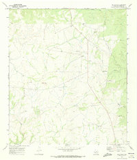
The Blue Hills rise above a landscape of deep-cut drainages in this remote section of Val Verde County, mapped at the start of the 1970s. The region is defined by its ranching infrastructure, featuring isolated outposts like Albers Ranch, Quinn Ranch, and Mayfield Ranch. These family-named holdings are supported by a network of unimproved roads, several Landing Strips, and numerous Water Tanks critical for livestock in the arid West Texas climate. The terrain is deeply incised by dry washes and canyons, most notably Duncan Draw to the north and the converging systems of Wallace Canyon, Sycamore Canyon, and Lewis Canyon to the south. Small-scale industrial activity is evidenced by a Gravel Pit and a Drill Hole, suggesting the persistent exploration of the land's subsurface potential alongside traditional pastoral use.
Find a feature on this map
14 named features on this map. Tap any name to fly to it.
Don’t see what you’re looking for? This feature index may not catch every label — zoom into the map to look around manually.
Map Details
Editions of this 1970 Blue Hills Map
2 editions found
Other maps of this area

1943 · Shumla
USGS Topo · 1:62,500

1944 · Baker Crossing
USGS Topo · 1:62,500

1954 · Sonora
USGS Topo · 1:250,000

1958 · Sonora
USGS Topo · 1:250,000

1958 · Del Rio
USGS Topo · 1:250,000

1964 · Del Rio
USGS Topo · 1:250,000

1970 · Everett Canyon
USGS Topo · 1:24,000

1970 · Steel Star Draw
USGS Topo · 1:24,000

1970 · Sycamore Canyon
USGS Topo · 1:24,000

1970 · Bee Canyon
USGS Topo · 1:24,000