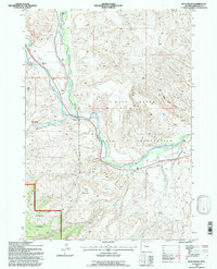
1991 Map of Blue Holes
USGS Topo · Published 1997About this map
The Wind River Indian Reservation meets the eastern edge of the Shoshone National Forest in this 1991 revision, showcasing a landscape defined by sharp administrative boundaries and significant hydrological features. The Wind River winds through the central terrain, joined by the East Fork Wind River and numerous tributaries like Blue Holes Creek and Miller Creek. This confluence of waters underscores the area's importance for resource management, reflected by the presence of the State Game and Fish Checking Station.
Find a feature on this map
22 named features on this map. Tap any name to fly to it.
Don’t see what you’re looking for? This feature index may not catch every label — zoom into the map to look around manually.
Map Details
Editions of this 1991 Blue Holes Map
This is the sole edition of this map. No revisions or reprints were ever made.
Other maps of this area

1904 · Kirwin
USGS Topo · 1:125,000

1905 · Younts Peak
USGS Topo · 1:125,000

1906 · Kirwin
USGS Topo · 1:125,000

1907 · Younts Peak
USGS Topo · 1:125,000

1909 · Fremont Peak
USGS Topo · 1:125,000

1952 · Wilderness
USGS Topo · 1:24,000

1952 · Hays Park
USGS Topo · 1:24,000

1952 · Blue Holes
USGS Topo · 1:24,000

1952 · Burris
USGS Topo · 1:24,000

1955 · Thermopolis
USGS Topo · 1:250,000