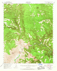
1946 Map of Blue House Mtn
USGS Topo · Published 1967About this map
Salt River carvings and steep ridge lines define this portion of the Arizona landscape, where the Fort Apache Indian Reservation and Tonto National Forest meet. The 1946 aerial survey reveals a specialized industrial and archaeological environment, capturing the location of several Cliff Dwellings tucked into the canyons near the Regal Mine and Apache Mine. This confluence of ancient habitation and mid-century resource extraction is concentrated along the river corridor and the high ground of Mustang Ridge.
Find a feature on this map
44 named features on this map. Tap any name to fly to it.
Don’t see what you’re looking for? This feature index may not catch every label — zoom into the map to look around manually.
Map Details
Editions of this 1946 Blue House Mtn Map
2 editions found
Other maps of this area

1886 · Holbrook
USGS Topo · 1:250,000

1893 · Holbrook
USGS Topo · 1:250,000

1922 · Chrysotile
USGS Topo · 1:125,000

1946 · Blue House Mtn
USGS Topo · 1:62,500

1949 · McFadden Peak
USGS Topo · 1:62,500

1949 · Rockinstraw Mtn
USGS Topo · 1:62,500

1950 · Rockinstraw Mtn
USGS Topo · 1:62,500

1950 · McFadden Peak
USGS Topo · 1:62,500

1951 · Blue House Mtn
USGS Topo · 1:62,500

1954 · Holbrook
USGS Topo · 1:250,000