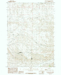
1985 Map of Blue Mesa East
USGS Topo · Published 1985About this map
Blue Mesa and the prominent Boulder Ridge dominate this central Wyoming landscape along the border of Washakie and Hot Springs counties. Compiled from 1976 aerial photography, the map reveals a complex network of drainage systems including Gooseberry Creek and Little Gooseberry Creek in the north, and Cottonwood Creek in the south. The terrain is deeply incised by features such as Boulder Gulch and Spring Gulch, indicating a highly eroded high-plains environment. A single named water source, Keg Spring, appears within one of these gulches, highlighting the significance of reliable water in this arid region. The boundary between the two counties is clearly delineated as it traverses the high ground of the ridge, offering a specific look at the jurisdictional divisions of the mid-1980s.
Find a feature on this map
11 named features on this map. Tap any name to fly to it.
Don’t see what you’re looking for? This feature index may not catch every label — zoom into the map to look around manually.
Map Details
Editions of this 1985 Blue Mesa East Map
This is the sole edition of this map. No revisions or reprints were ever made.
Other maps of this area

1914 · Blue Mesa
USGS Topo · 1:62,500

1916 · Blue Mesa
USGS Topo · 1:62,500

1945 · Kirby
USGS Topo · 1:62,500

1946 · Kirby
USGS Topo · 1:62,500

1951 · Dutch Nick Flat
USGS Topo · 1:24,000

1951 · Schuster Flats
USGS Topo · 1:24,000

1951 · Dutch Nick Flat SW
USGS Topo · 1:24,000

1955 · Cody
USGS Topo · 1:250,000

1955 · Thermopolis
USGS Topo · 1:250,000

1958 · Cody
USGS Topo · 1:250,000