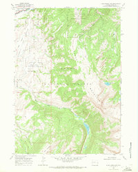
1968 Map of Blue Miner Lake
USGS Topo · Published 1971About this map
The Gros Ventre Slide Geological Area dominates the northern landscape of this Wyoming survey, documenting the site of the massive 1925 landslide. To the west, the National Elk Refuge and Teton Game Management Area represent the region's long-standing dedication to wildlife conservation at the edge of Grand Teton Nat Park. The map reveals the isolation of early backcountry outposts like Teton Valley Ranch along the Gros Ventre River and Flat Creek Ranch deep within the Teton National Forest. High-altitude features including Sheep Mountain, Table Mountain, and the namesake Blue Miner Lake are connected only by a network of rudimentary trails. This record is particularly valuable for those tracing the history of recreation and remote ranching in Teton County before modern development reached these higher elevations.
Find a feature on this map
21 named features on this map. Tap any name to fly to it.
Don’t see what you’re looking for? This feature index may not catch every label — zoom into the map to look around manually.
Map Details
Editions of this 1968 Blue Miner Lake Map
This is the sole edition of this map. No revisions or reprints were ever made.
Other maps of this area

1899 · Grand Teton
USGS Topo · 1:125,000

1901 · Grand Teton
USGS Topo · 1:125,000

1902 · Mt Leidy
USGS Topo · 1:125,000

1907 · Gros Ventre
USGS Topo · 1:125,000

1910 · Gros Ventre
USGS Topo · 1:125,000

1931 · Jackson
USGS Topo · 1:125,000

1935 · Jackson
USGS Topo · 1:125,000

1955 · Driggs
USGS Topo · 1:250,000

1958 · Driggs
USGS Topo · 1:250,000

1962 · Driggs
USGS Topo · 1:250,000