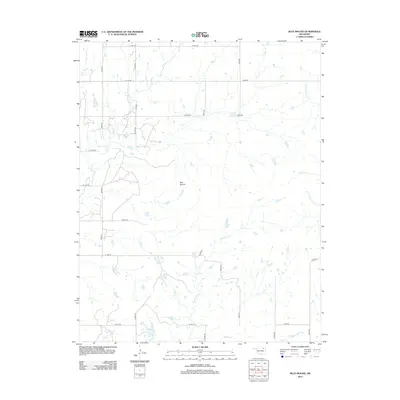
2012 Map of Blue Mound
USGS Topo · Published 2012About this map
Blue Mound rises as a prominent landmark above the surrounding creek systems in this part of Washington County. The landscape is defined by an intricate network of waterways, most notably Hogshooter Cr and Coon Cr, which drain the undulating terrain into various ponds and tributaries. This 2012 survey illustrates the modern rural infrastructure of the region, where a structured grid of county roads like N 4010 RD and W 1200 RD provides access to the interior. The drainage patterns of Little California Cr and the forks of Wolf Creek reveal the natural topography that has influenced land use in this section of Oklahoma for generations. Local historians can trace the relationship between these ancient watercourses and the contemporary road network that follows the section lines.
Find a feature on this map
27 named features on this map. Tap any name to fly to it.
Don’t see what you’re looking for? This feature index may not catch every label — zoom into the map to look around manually.
Map Details
Editions of this 2012 Blue Mound Map
This is the sole edition of this map. No revisions or reprints were ever made.
Other maps of this area

1901 · Nowata
USGS Topo · 1:125,000

1914 · Nowata
USGS Topo · 1:125,000

1954 · Tulsa
USGS Topo · 1:250,000

1958 · Tulsa
USGS Topo · 1:250,000

1963 · Tulsa
USGS Topo · 1:250,000
1971 · Bartlesville South
USGS Topo · 1:24,000
1971 · Bartlesville North
USGS Topo · 1:24,000

1972 · Blue Mound
USGS Topo · 1:24,000
1972 · Elliott
USGS Topo · 1:24,000

1972 · Nowata West
USGS Topo · 1:24,000