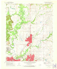
1971 Map of Bartlesville North
USGS Topo · Published 1973About this map
The Caney River snakes through the landscape of northern Washington Co., dividing the dense grid of Bartlesville and Dewey from the expansive petroleum operations to the east and west. This 1971 survey illustrates a transition era where the regional economy was deeply tied to the Jefferson Oil Field and the Missouri - Kansas - Texas Oil Field, marked by numerous gas wells and storage facilities. The transportation network is dominated by the Santa Fe railroad and the Missouri - Kansas - Texas and Atchison Topeka and Santa Fe line, which provided the essential infrastructure for moving oil and goods through the heart of Dewey. Local community life is visible through the positioning of the Antioch Ch and various schools like Lincoln Sch, while the presence of the Hi Way Airport and Wayside Airport signals the importance of regional aviation during the early 1970s.
Find a feature on this map
47 named features on this map. Tap any name to fly to it.
Don’t see what you’re looking for? This feature index may not catch every label — zoom into the map to look around manually.
Map Details
Editions of this 1971 Bartlesville North Map
2 editions found
Other maps of this area

1901 · Nowata
USGS Topo · 1:125,000

1909 · Pawhuska
USGS Topo · 1:125,000

1910 · Pawhuska
USGS Topo · 1:125,000

1914 · Nowata
USGS Topo · 1:125,000

1954 · Tulsa
USGS Topo · 1:250,000

1955 · Enid
USGS Topo · 1:250,000

1958 · Enid
USGS Topo · 1:250,000

1958 · Tulsa
USGS Topo · 1:250,000

1963 · Tulsa
USGS Topo · 1:250,000
1971 · Bowring
USGS Topo · 1:24,000