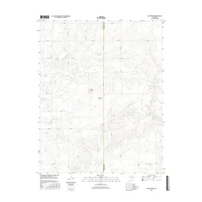
2016 Map of Blue Mound
USGS Topo · Published 2016About this map
Blue Mound rises as a prominent landmark in this northeastern Oklahoma landscape, situated along the county line where Washington County meets Nowata County. The terrain is defined by a dense network of drainage systems, including Hogshooter Cr and the winding paths of Coon Cr and Coon Creek. This 2016 survey illustrates a rural environment increasingly modified by water management, as seen in the presence of the Cotton Coon Mission Site Number 12 Reservoir and the D B Dutcher Number 3 Reservoir. Local naming conventions reflect both the physical geography, such as Limestone Draw, and personal histories tied to the land. The map provides a detailed view of the section-line road network, including thoroughfares like Tuxedo Blvd and Durham Rd, which serve the dispersed homesteads and agricultural operations of the region.
Find a feature on this map
40 named features on this map. Tap any name to fly to it.
Don’t see what you’re looking for? This feature index may not catch every label — zoom into the map to look around manually.
Map Details
Editions of this 2016 Blue Mound Map
This is the sole edition of this map. No revisions or reprints were ever made.
Other maps of this area

1901 · Nowata
USGS Topo · 1:125,000

1914 · Nowata
USGS Topo · 1:125,000

1954 · Tulsa
USGS Topo · 1:250,000

1958 · Tulsa
USGS Topo · 1:250,000

1963 · Tulsa
USGS Topo · 1:250,000
1971 · Bartlesville South
USGS Topo · 1:24,000
1971 · Bartlesville North
USGS Topo · 1:24,000

1972 · Blue Mound
USGS Topo · 1:24,000
1972 · Elliott
USGS Topo · 1:24,000

1972 · Nowata West
USGS Topo · 1:24,000