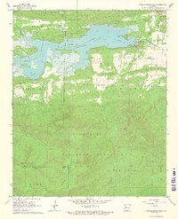
1966 Map of Blue Mountain Dam
USGS Topo · Published 1967About this map
Blue Mountain Lake dominates the upper half of this mid-1960s landscape, created by the Blue Mountain Dam across the Petit Jean River. The impoundment reached into the corners of Yell and Logan counties, creating a sprawling shoreline dotted with public access points like the Ashley Creek Recreation Area and Waveland Park Recreation Area. South of the lake, the terrain rises sharply into the Ouachita National Forest, a heavily wooded expanse of ridges including Potato Hill Mountain and Rich Land.
Find a feature on this map
42 named features on this map. Tap any name to fly to it.
Don’t see what you’re looking for? This feature index may not catch every label — zoom into the map to look around manually.
Map Details
Editions of this 1966 Blue Mountain Dam Map
3 editions found
Other maps of this area

1879 · Mountain Home
USGS Topo · 1:62,500

1887 · Magazine Mountain #4
USGS Topo · 1:62,500

1887 · Mount Ida #2
USGS Topo · 1:62,500

1887 · Magazine Mountain #3
USGS Topo · 1:62,500

1887 · Magazine Mountain
USGS Topo · 1:62,500

1890 · Magazine Mountain
USGS Topo · 1:125,000

1890 · Mount Ida
USGS Topo · 1:125,000

1934 · Booneville
USGS Topo · 1:48,000

1939 · Booneville
USGS Topo · 1:62,500

1955 · Little Rock
USGS Topo · 1:250,000