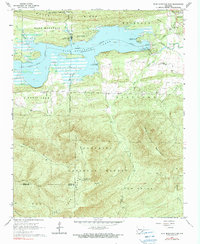
1966 Map of Blue Mountain Dam
USGS Topo · Published 1990About this map
Blue Mountain Lake dominates the northern landscape of this Yell County region, formed by the construction of the Blue Mountain Dam across the Petit Jean River. The mid-1960s survey captures the area's transition into a recreational hub, featuring sites like Waveland Park Recreation Area and Ashley Creek Recreation Area along the shoreline. North of the water, the settlement of Waveland sits near the base of Potts Ridge, while the rugged southern terrain ascends into the Ouachita National Forest.
Find a feature on this map
40 named features on this map. Tap any name to fly to it.
Don’t see what you’re looking for? This feature index may not catch every label — zoom into the map to look around manually.
Map Details
Editions of this 1966 Blue Mountain Dam Map
3 editions found
Other maps of this area

1879 · Mountain Home
USGS Topo · 1:62,500

1887 · Magazine Mountain #4
USGS Topo · 1:62,500

1887 · Mount Ida #2
USGS Topo · 1:62,500

1887 · Magazine Mountain #3
USGS Topo · 1:62,500

1887 · Magazine Mountain
USGS Topo · 1:62,500

1890 · Magazine Mountain
USGS Topo · 1:125,000

1890 · Mount Ida
USGS Topo · 1:125,000

1934 · Booneville
USGS Topo · 1:48,000

1939 · Booneville
USGS Topo · 1:62,500

1955 · Little Rock
USGS Topo · 1:250,000