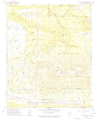
1966 Map of Blue Mountain
USGS Topo · Published 1978About this map
Magazine Mountain dominates this landscape, reaching its peak at Signal Hill and offering a developed recreation area featuring the Magazine Mountain Lodge and Cameron Bluff Recreation Area. In the mid-1960s, the southern portion of the map centers on the small settlement of Blue Mountain, situated along the Chicago Rock Island and Pacific railroad line near the Logan and Yell County border. This area within the Ozark National Forest is characterized by its numerous natural springs and family-named cemeteries, including the Jenkins, Rana, and Shaw cemeteries. To the north, the terrain transitions into Rich Mountain and Short Mountain, while the northeast corner shows the developed shores of Cove Lake. The map reveals a network of ridges like Mossback Ridge and Donathan Ridge, interspersed with numerous creeks and the remnants of rural community life centered around places like Liberty Ch and the village of Corley.
Find a feature on this map
64 named features on this map. Tap any name to fly to it.
Don’t see what you’re looking for? This feature index may not catch every label — zoom into the map to look around manually.
Map Details
Editions of this 1966 Blue Mountain Map
2 editions found
Other maps of this area

1879 · Mountain Home
USGS Topo · 1:62,500

1887 · Magazine Mountain #1
USGS Topo · 1:62,500

1887 · Magazine Mountain #4
USGS Topo · 1:62,500

1887 · Magazine Mountain #2
USGS Topo · 1:62,500

1887 · Magazine Mountain #3
USGS Topo · 1:62,500

1887 · Magazine Mountain
USGS Topo · 1:62,500

1890 · Magazine Mountain
USGS Topo · 1:125,000

1934 · Booneville
USGS Topo · 1:48,000

1939 · Booneville
USGS Topo · 1:62,500

1956 · Russellville
USGS Topo · 1:250,000