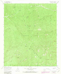
1964 Map of Blue Mountain
USGS Topo · Published 1981About this map
Apache Kid Peak and the high summits of the San Mateo Mountains dominate this high-altitude landscape within the Cibola National Forest. This 1964 survey, revised in 1981, reveals a complex network of deep drainages and ridges, including the prominent Skeleton Ridge and the broad Tonto Basin to the southeast. The map is particularly rich in named water sources vital to this arid environment, such as Hardscrabble Spring, Old Hidden Spring, and Cow Trap Spring.
Find a feature on this map
51 named features on this map. Tap any name to fly to it.
Don’t see what you’re looking for? This feature index may not catch every label — zoom into the map to look around manually.
Map Details
Editions of this 1964 Blue Mountain Map
4 editions found
Other maps of this area

1954 · Tularosa
USGS Topo · 1:250,000

1958 · Tularosa
USGS Topo · 1:250,000

1964 · Welty Hill
USGS Topo · 1:24,000

1964 · Vicks Peak
USGS Topo · 1:24,000

1964 · San Juan Peak
USGS Topo · 1:24,000

1964 · Bay Buck Peaks
USGS Topo · 1:24,000

1964 · Blue Mountain
USGS Topo · 1:24,000

1964 · Montoya Butte
USGS Topo · 1:24,000

1964 · Steel Hill
USGS Topo · 1:24,000
1964 · Grassy Lookout
USGS Topo · 1:24,000