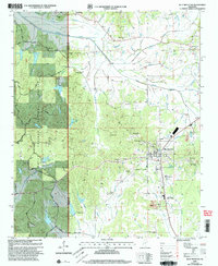
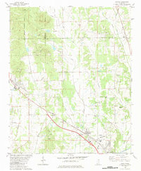
2000 Map of Blue Mountain
USGS Topo · Published 2003About this map
Blue Mountain sits at the heart of this North Mississippi landscape, where the town's character is defined by its educational and religious institutions. The presence of the Blue Mountain Childrens Home and the Blue Mountain Ch athletic field points to a community built around local assembly and social services. To the west, the Holly Springs National Forest marks a distinct boundary between the town's development and the wooded terrain of the Heips Hills, while names like Beulah Hill Ch and St James Ch suggest a landscape dotted with historically significant country churches.
Find a feature on this map
80 named features on this map. Tap any name to fly to it.
Don’t see what you’re looking for? This feature index may not catch every label — zoom into the map to look around manually.
Map Details
Editions of this 2000 Blue Mountain Map
This is the sole edition of this map. No revisions or reprints were ever made.
Other maps of this area

1950 · Ashland
USGS Topo · 1:62,500

1951 · Walnut
USGS Topo · 1:62,500

1955 · Ripley
USGS Topo · 1:62,500

1955 · Blue Mountain
USGS Topo · 1:62,500

1956 · Tupelo
USGS Topo · 1:250,000

1958 · Tupelo
USGS Topo · 1:250,000
1982 · Keownville
USGS Topo · 1:24,000
1982 · Ripley
USGS Topo · 1:24,000
1982 · Blue Mountain
USGS Topo · 1:24,000
1982 · Myrtle
USGS Topo · 1:24,000