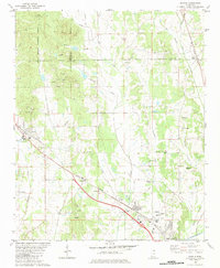
1982 Map of Myrtle
USGS Topo · Published 1983About this map
The Heipsy Hills dominate the northern landscape of this region where the borders of Benton, Tippah, and Union counties converge. A distinctive network of country churches and family burial grounds, including Zion Hill Ch, Bethlehem Ch, and McAllister Cem, marks the rural social fabric outside the principal settlement of Myrtle. The southern portion of the map reveals the transition from higher ground into the river bottomlands near the Tallahatchie R, where smaller communities like Glenfield and Pumpkin Center are situated.
Find a feature on this map
58 named features on this map. Tap any name to fly to it.
Don’t see what you’re looking for? This feature index may not catch every label — zoom into the map to look around manually.
Map Details
Editions of this 1982 Myrtle Map
This is the sole edition of this map. No revisions or reprints were ever made.
Other maps of this area

1949 · New Albany
USGS Topo · 1:62,500

1951 · New Albany
USGS Topo · 1:62,500

1955 · Ripley
USGS Topo · 1:62,500

1955 · Sherman
USGS Topo · 1:62,500

1955 · Blue Mountain
USGS Topo · 1:62,500

1956 · Tupelo
USGS Topo · 1:250,000

1958 · Tupelo
USGS Topo · 1:250,000

1980 · New Albany West
USGS Topo · 1:24,000
1980 · New Albany East
USGS Topo · 1:24,000
1980 · Etta
USGS Topo · 1:24,000