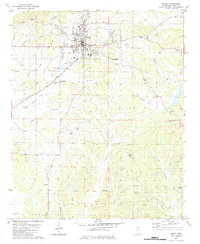
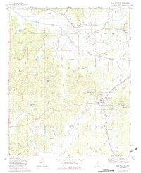
1982 Map of Ripley
USGS Topo · Published 1983About this map
The town of Ripley anchors this northern Mississippi landscape, serving as a hub for the surrounding agricultural and timbered terrain in the early 1980s. The Illinois Central Gulf railroad cuts a diagonal path through the center of the region, passing by the Fairground and local industrial sites like the Claypit and several Sandpits. This transit corridor historically shaped the growth of the town, connecting it to the broader commerce of Tippah County while outlying communities like New Hope and Clarysville remained oriented toward the creek bottoms.
Find a feature on this map
60 named features on this map. Tap any name to fly to it.
Don’t see what you’re looking for? This feature index may not catch every label — zoom into the map to look around manually.
Map Details
Editions of this 1982 Ripley Map
This is the sole edition of this map. No revisions or reprints were ever made.
Other maps of this area

1950 · Ashland
USGS Topo · 1:62,500

1951 · Walnut
USGS Topo · 1:62,500

1955 · Ripley
USGS Topo · 1:62,500

1955 · Blue Mountain
USGS Topo · 1:62,500

1956 · Tupelo
USGS Topo · 1:250,000

1958 · Tupelo
USGS Topo · 1:250,000
1982 · Keownville
USGS Topo · 1:24,000
1982 · Dumas
USGS Topo · 1:24,000
1982 · Pleasant Ridge
USGS Topo · 1:24,000
1982 · Blue Mountain
USGS Topo · 1:24,000