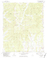
1982 Map of Pleasant Ridge
USGS Topo · Published 1983About this map
Pleasant Ridge and Jericho anchor this early 1980s topographic study of the rural landscape where Tippah and Union counties meet. The terrain is defined by the headwaters of the Hatchie River, which winds through the center of the sheet fed by numerous local tributaries like Owens Br and Caney Br. Evidence of early 20th-century industry persists at Oil Mill Hill and the remnants of an Oil Mill further north, while the presence of scattered sandpits suggests the ongoing extraction of local resources. For genealogists, the map is remarkably dense with family-named landmarks and burial grounds, including the Pickens Cem, Stubb Cem, and Bartlett Cem, alongside established rural congregations such as Mt Zion Ch. This detailed mapping of fence and field lines provides a clear view of the agricultural patterns before modern consolidation.
Find a feature on this map
52 named features on this map. Tap any name to fly to it.
Don’t see what you’re looking for? This feature index may not catch every label — zoom into the map to look around manually.
Map Details
Editions of this 1982 Pleasant Ridge Map
This is the sole edition of this map. No revisions or reprints were ever made.
Other maps of this area

1921 · Booneville
USGS Topo · 1:48,000

1921 · Tupelo
USGS Topo · 1:48,000

1922 · Booneville
USGS Topo · 1:62,500

1923 · Tupelo
USGS Topo · 1:62,500

1955 · Ripley
USGS Topo · 1:62,500

1955 · Sherman
USGS Topo · 1:62,500

1956 · Tupelo
USGS Topo · 1:250,000

1958 · Tupelo
USGS Topo · 1:250,000

1972 · Jumpertown
USGS Topo · 1:24,000

1973 · Guntown
USGS Topo · 1:24,000