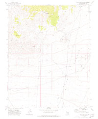
1973 Map of Blue Nose Peak
USGS Topo · Published 1977About this map
Blue Nose Peak rises as the central topographical landmark in this arid portion of Lincoln County, overlooking the expansive drainage of the Tule Desert. The landscape is defined by the ephemeral flow of Garden Wash and Rocks Camp Wash, where seasonal water management is evidenced by several dams and the remote White Rock Reservoir. Human activity in this high-desert environment is largely centered on resource extraction and livestock, as indicated by numerous prospects and mines scattered across the northern slopes. A network of jeep trails provides the only access through the basin, connecting isolated points of interest such as the End of the Line Trough and the natural catchments at Dodge Pockets. The survey captures a moment when traditional land use—mining and ranching—remained the primary imprint on the Nevada desert.
Find a feature on this map
19 named features on this map. Tap any name to fly to it.
Don’t see what you’re looking for? This feature index may not catch every label — zoom into the map to look around manually.
Map Details
Editions of this 1973 Blue Nose Peak Map
This is the sole edition of this map. No revisions or reprints were ever made.
Other maps of this area

1885 · Pioche
USGS Topo · 1:250,000

1886 · Pioche
USGS Topo · 1:250,000

1954 · Caliente
USGS Topo · 1:250,000

1959 · Caliente
USGS Topo · 1:250,000
1973 · Leith
USGS Topo · 1:24,000
1973 · Jacks Mountain
USGS Topo · 1:24,000
1973 · Tule Spring
USGS Topo · 1:24,000
1973 · Lime Mountain
USGS Topo · 1:24,000
1973 · Toquop Gap
USGS Topo · 1:24,000
1973 · Lyman Crossing
USGS Topo · 1:24,000